
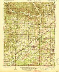
1944 Map of Naylor
USGS Topo · Published 1944About this map
The Little Black River and the Black River define the winding drainage patterns of this 1940s landscape on the Missouri Arkansas border. This area showcases a dense network of early rural social infrastructure, with dozens of family-named and local schools such as Mackintosh Sch, Forest Grove Sch, and Venerable Sch serving scattered communities. The infrastructure is heavily influenced by the presence of the Military Road and the Old Military Road, which cut through the hills near Fairdealing. Regional transport is further anchored by the St Louis San Francisco and Missouri Pacific railroads, which facilitated the movement of goods through junctions like Naylor and Neelyville. The presence of numerous fords, such as Pennington Ford and Brown Ford, indicates a landscape where river crossings were still critical seasonal landmarks for local travel between settlements like Oxly and Gamburg.
Find a feature on this map
91 named features on this map. Tap any name to fly to it.
Don’t see what you’re looking for? This feature index may not catch every label — zoom into the map to look around manually.
Map Details
Editions of this 1944 Naylor Map
2 editions found
Other maps of this area

1934 · Williamsville
USGS Topo · 1:48,000

1935 · Poplar Bluff
USGS Topo · 1:62,500

1935 · Acorn
USGS Topo · 1:62,500

1935 · Rector
USGS Topo · 1:62,500

1935 · Knobel
USGS Topo · 1:62,500

1935 · Reyno
USGS Topo · 1:62,500

1935 · Harviell
USGS Topo · 1:62,500

1939 · Poplar Bluff
USGS Topo · 1:62,500

1939 · Doniphan
USGS Topo · 1:62,500

1940 · Williamsville
USGS Topo · 1:62,500