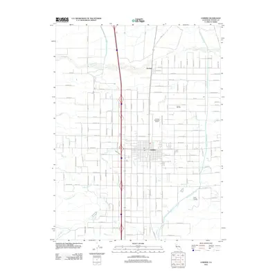
2012 Map of Corning
USGS Topo · Published 2012About this map
Corning and the nearby community of Richfield anchor this 2012 survey, which illustrates the complex water management system of the northern Sacramento Valley. The landscape is defined by the parallel paths of the Corning Canal and the Tehama Colusa Canal, which supply the agricultural interests of Tehama County. Natural drainage is still prominent, however, with numerous waterways like Thomes Creek, Jewett Creek, and the multiple branches of Hall Creek cutting west to east across the terrain.
Find a feature on this map
100 named features on this map. Tap any name to fly to it.
Don’t see what you’re looking for? This feature index may not catch every label — zoom into the map to look around manually.
Map Details
Editions of this 2012 Corning Map
This is the sole edition of this map. No revisions or reprints were ever made.
Other maps of this area

1890 · Red Bluff
USGS Topo · 1:250,000

1894 · Red Bluff
USGS Topo · 1:250,000

1904 · Vina
USGS Topo · 1:62,500

1905 · Tehama
USGS Topo · 1:62,500

1914 · Kirkwood
USGS Topo · 1:31,680

1914 · McIntosh Landing
USGS Topo · 1:31,680

1944 · Flournoy
USGS Topo · 1:62,500
1949 · Kirkwood
USGS Topo · 1:24,000
1950 · Kirkwood
USGS Topo · 1:24,000
1950 · Vina
USGS Topo · 1:24,000