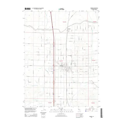
2015 Map of Corning
USGS Topo · Published 2015About this map
Corning and the smaller settlement of Richfield anchor this section of Tehama County, characterized by a complex network of irrigation and seasonal drainages. The landscape is defined by the critical infrastructure of the Tehama Colusa Canal and the Corning Canal, which parallel the Interstate corridor to support the region's agricultural production. Numerous watercourses, including Thomes Cr, Jewett Cr, and Burch Creek, cross the valley floor, flowing generally eastward from the Coast Range foothills toward the Sacramento River. This 2015 survey shows a grid-like settlement pattern dominated by long avenues and roads, such as Gallagher Ave and Corning Rd, which connect the town center to the outlying orchards and fields. The Corning Municipal Airport sits just north of the city center, serving as a local transportation hub amidst a terrain punctuated by the various forks of Hall Creek.
Find a feature on this map
127 named features on this map. Tap any name to fly to it.
Don’t see what you’re looking for? This feature index may not catch every label — zoom into the map to look around manually.
Map Details
Editions of this 2015 Corning Map
This is the sole edition of this map. No revisions or reprints were ever made.
Other maps of this area

1890 · Red Bluff
USGS Topo · 1:250,000

1894 · Red Bluff
USGS Topo · 1:250,000

1904 · Vina
USGS Topo · 1:62,500

1905 · Tehama
USGS Topo · 1:62,500

1914 · Kirkwood
USGS Topo · 1:31,680

1914 · McIntosh Landing
USGS Topo · 1:31,680

1944 · Flournoy
USGS Topo · 1:62,500
1949 · Kirkwood
USGS Topo · 1:24,000
1950 · Kirkwood
USGS Topo · 1:24,000
1950 · Vina
USGS Topo · 1:24,000