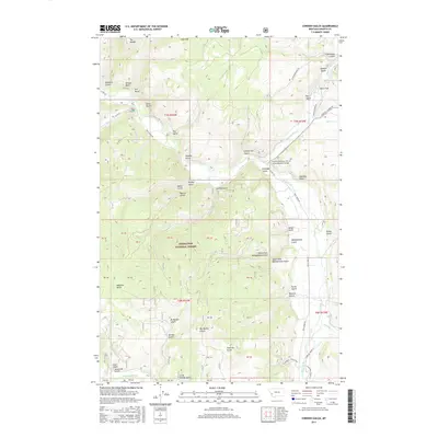
2017 Map of Cornish Gulch
USGS Topo · Published 2017About this map
Deerlodge National Forest dominates this landscape in Granite County, where the drainages of Stony Cr and Rock Creek carve through a network of named gulches and ridges. The topography is defined by high points like Ram Mtn, The Wedge, and Wright Rock, which overlook a region shaped by resource extraction and high-altitude surveying. Numerous drainages such as Bi-Metalic Gulch, Aurora Gulch, and Big Moffat Gulch suggest a history of prospecting, while larger water bodies like Upper Willow Cr and Spring Cr frame the eastern portion of the quadrangle.
Find a feature on this map
72 named features on this map. Tap any name to fly to it.
Don’t see what you’re looking for? This feature index may not catch every label — zoom into the map to look around manually.
Map Details
Editions of this 2017 Cornish Gulch Map
This is the sole edition of this map. No revisions or reprints were ever made.
Other maps of this area

1908 · Philipsburg
USGS Topo · 1:125,000

1909 · Sapphire
USGS Topo · 1:125,000

1947 · Butte
USGS Topo · 1:250,000

1958 · Butte
USGS Topo · 1:250,000

1960 · Butte
USGS Topo · 1:250,000

1962 · Butte
USGS Topo · 1:250,000

1971 · Antelope Creek
USGS Topo · 1:24,000

1971 · Potato Lakes
USGS Topo · 1:24,000
1971 · Black Pine Ridge
USGS Topo · 1:24,000

1971 · Stony Creek
USGS Topo · 1:24,000