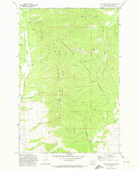
1971 Map of Black Pine Ridge
USGS Topo · Published 1973About this map
Deerlodge National Forest covers this high-elevation landscape in Granite County during the early 1970s. The map is dominated by the massive north-south spine of the John Mountains, topped by Black Pine Ridge. This area was an active site for resource management and mining exploration, evidenced by the numerous Drill Holes, Mines, and Prospects scattered across the drainages.
Find a feature on this map
34 named features on this map. Tap any name to fly to it.
Don’t see what you’re looking for? This feature index may not catch every label — zoom into the map to look around manually.
Map Details
Editions of this 1971 Black Pine Ridge Map
2 editions found
Other maps of this area

1903 · Bonner
USGS Topo · 1:125,000

1908 · Philipsburg
USGS Topo · 1:125,000

1909 · Sapphire
USGS Topo · 1:125,000

1919 · Drummond
USGS Topo · 1:125,000

1921 · Drummond
USGS Topo · 1:125,000

1947 · Butte
USGS Topo · 1:250,000

1958 · Butte
USGS Topo · 1:250,000

1959 · Bearmouth
USGS Topo · 1:62,500

1959 · Ravenna
USGS Topo · 1:62,500

1960 · Butte
USGS Topo · 1:250,000