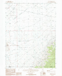
1987 Map of Cornish Peak
USGS Topo · Published 1988About this map
The Stillwater Range dominates the eastern landscape of this Nevada survey, where the high desert terrain transitions into steep, rugged peaks. Historical mining activity is concentrated in the mountainous corridors, specifically near New York Canyon and Cornish Canyon. Notable sites for local history and mineral research include the Green Gold Mine and several other unnamed Mine and Mine Shaft locations. To the west, the arid basins of Buena Vista Valley and Antelope Valley reveal a very different character, marked by drainage patterns leading toward the Alkali Flat. Tracing through the northwestern corner, the historic Emigrant Trail provides a physical connection to the era of westward expansion, winding past distinctive landmarks like Chocolate Butte. The boundary between Pershing Co and Churchill Co bisects the southern reaches of the quadrangle near Cornish Peak.
Find a feature on this map
18 named features on this map. Tap any name to fly to it.
Don’t see what you’re looking for? This feature index may not catch every label — zoom into the map to look around manually.
Map Details
Editions of this 1987 Cornish Peak Map
This is the sole edition of this map. No revisions or reprints were ever made.
Other maps of this area

1908 · Carson Sink
USGS Topo · 1:250,000

1910 · Carson Sink
USGS Topo · 1:250,000

1931 · Lovelock
USGS Topo · 1:250,000

1932 · Sonoma Range
USGS Topo · 1:250,000

1935 · Lovelock
USGS Topo · 1:250,000

1939 · Sonoma Range
USGS Topo · 1:250,000

1954 · Buffalo Mtn
USGS Topo · 1:62,500

1955 · Millett
USGS Topo · 1:250,000

1955 · Lovelock
USGS Topo · 1:250,000

1955 · Winnemucca
USGS Topo · 1:250,000