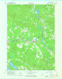
1964 Map of Cornish
USGS Topo · Published 1977About this map
The Saco River and Ossipee River converge near the town of Cornish in this mid-1960s survey of southwestern Maine. The landscape is defined by its deep river valleys and numerous named peaks, including Gould Mtn and Pease Mtn. The Maine Central railroad tracks follow the eastern bank of the Saco, passing through West Baldwin and Cornish Station. This map is particularly dense with genealogical detail, featuring more than twenty small family and community burial grounds such as Riverside Cem, Edgecomb Cem, and the Gould-Bradeen Cem. Traces of local recreation and industry appear in the form of the Fairgrounds south of the Ossipee, a Drive-in Theater, and various Gravel Pits concentrated near the water. The survey also notes many residential and field boundaries with fine red lines, providing a detailed look at the rural property layout of the era.
Find a feature on this map
74 named features on this map. Tap any name to fly to it.
Don’t see what you’re looking for? This feature index may not catch every label — zoom into the map to look around manually.
Map Details
Editions of this 1964 Cornish Map
3 editions found
Other maps of this area

1891 · Buxton
USGS Topo · 1:62,500

1891 · Newfield
USGS Topo · 1:62,500

1892 · Buxton
USGS Topo · 1:62,500

1893 · Buxton
USGS Topo · 1:62,500

1893 · Newfield
USGS Topo · 1:62,500

1896 · Sebago
USGS Topo · 1:62,500

1910 · Kezar Falls
USGS Topo · 1:48,000

1911 · Kezar Falls
USGS Topo · 1:62,500

1933 · Newfield
USGS Topo · 1:48,000

1937 · Newfield
USGS Topo · 1:62,500