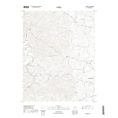
2019 Map of Cornishville
USGS Topo · Published 2019About this map
The Chaplin River and the Salt River frame this landscape of Mercer County, Kentucky, where the topography is defined by the tight drainage patterns of Deep Cr, Thompson Creek, and Grapevine Cr. This area remains largely rural and agricultural, characterized by its numerous small settlements and family-named cemeteries. For those tracing local history, the map provides precise locations for Mayo Church Cem and Hopewell Church Cem in the north, and Berea Cem and Oakland Cem in the south near the Mackville Rd corridor. The community of Cornishville sits as a central hub, connected to outlying hamlets like Bohon and Bushtown by a network of historic pikes and lanes. These roads, such as Central Pike and Jackson Pike, follow the ridgelines and creek valleys, reflecting the region's long-standing reliance on its natural watercourses for orientation and travel.
Find a feature on this map
47 named features on this map. Tap any name to fly to it.
Don’t see what you’re looking for? This feature index may not catch every label — zoom into the map to look around manually.
Map Details
Editions of this 2019 Cornishville Map
This is the sole edition of this map. No revisions or reprints were ever made.
Other maps of this area

1905 · Harrodsburg
USGS Topo · 1:125,000

1952 · Perryville
USGS Topo · 1:24,000

1952 · Danville
USGS Topo · 1:24,000

1952 · Harrodsburg
USGS Topo · 1:24,000

1952 · Cornishville
USGS Topo · 1:24,000

1952 · Ashbrook
USGS Topo · 1:24,000

1952 · Salvisa
USGS Topo · 1:24,000

1952 · Mc Brayer
USGS Topo · 1:24,000

1953 · Mackville
USGS Topo · 1:24,000

1953 · Cardwell
USGS Topo · 1:24,000