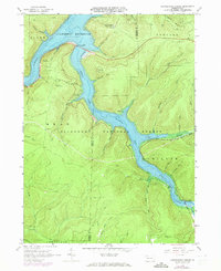
1966 Map of Cornplanter Bridge
USGS Topo · Published 1973About this map
Allegheny Reservoir dominates this landscape in the heart of the Allegheny National Forest, where the flooded valleys of the Allegheny River and Kinzua Creek converge. The mapping shows the area in a state of transition following the reservoir's creation, with recreational sites such as Kiasutha Recreational Area, Camp Cornplanter, and Dewdrop Campgrounds lining the new shoreline. The high ground remains defined by its industrial and surveillance history, evidenced by the Coal Knob Lookout Tower and numerous Oil Wells scattered across the ridges.
Find a feature on this map
62 named features on this map. Tap any name to fly to it.
Don’t see what you’re looking for? This feature index may not catch every label — zoom into the map to look around manually.
Map Details
Editions of this 1966 Cornplanter Bridge Map
3 editions found
Other maps of this area

1906 · Warren
USGS Topo · 1:62,500

1907 · Warren
USGS Topo · 1:62,500

1908 · Warren
USGS Topo · 1:62,500

1934 · Kane
USGS Topo · 1:48,000

1935 · Sheffield
USGS Topo · 1:48,000

1936 · Kinzua
USGS Topo · 1:48,000

1939 · Kane
USGS Topo · 1:62,500

1941 · Sheffield
USGS Topo · 1:62,500

1941 · Kinzua
USGS Topo · 1:62,500
1949 · Kinzua
USGS Topo · 1:62,500
Featured Places
- Sheffield Township, PA
- Glade Township, PA
- Mead Township, PA
- Hamilton Township, PA
- Elijah, Hamilton Township