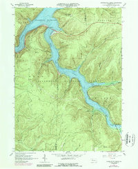
1966 Map of Cornplanter Bridge
USGS Topo · Published 1989About this map
Allegheny Reservoir dominates this landscape, its waters filling the valley floors between the steep ridges of the Allegheny National Forest. This 1960s survey documents the area shortly after the reservoir’s normal pool elevation reached 1328 feet, reshaping the geography of the Corydon and Hamilton regions. The iconic Cornplanter Bridge spans the narrowed northern reaches of the water, connecting the mountain roads above Kinzua Creek.
Find a feature on this map
60 named features on this map. Tap any name to fly to it.
Don’t see what you’re looking for? This feature index may not catch every label — zoom into the map to look around manually.
Map Details
Editions of this 1966 Cornplanter Bridge Map
3 editions found
Other maps of this area

1906 · Warren
USGS Topo · 1:62,500

1907 · Warren
USGS Topo · 1:62,500

1908 · Warren
USGS Topo · 1:62,500

1934 · Kane
USGS Topo · 1:48,000

1935 · Sheffield
USGS Topo · 1:48,000

1936 · Kinzua
USGS Topo · 1:48,000

1939 · Kane
USGS Topo · 1:62,500

1941 · Sheffield
USGS Topo · 1:62,500

1941 · Kinzua
USGS Topo · 1:62,500
1949 · Kinzua
USGS Topo · 1:62,500
Featured Places
- Sheffield Township, PA
- Glade Township, PA
- Mead Township, PA
- Hamilton Township, PA
- Elijah, Hamilton Township