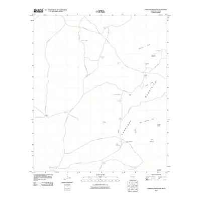
2010 Map of Cornudas Mountain
USGS Topo · Published 2010About this map
Cornudas Mountains define this high-desert region on the New Mexico-Texas border, where water management is central to the landscape. Cattle ranching and mineral exploration are evidenced by the presence of Cornudas Ranch and the Cornudas Mountain Prospect on the eastern slopes. A network of county roads, including Dell City Rd and County Rd-F015, connects various water features necessary for survival in this arid environment, such as Alamo Windmill, Chess Well, and numerous catchment basins like Harris Tank and Vince Tank. The topography is marked by significant peaks like Wind Mountain and Deer Mountain, with drainage provided by the prominent Cornudas Draw and Chess Draw. This 2010 survey reflects a modern period of continued land use in Otero County, where naming conventions often follow the terrain, from Flat Top to the southern State Line Tank.
Find a feature on this map
40 named features on this map. Tap any name to fly to it.
Don’t see what you’re looking for? This feature index may not catch every label — zoom into the map to look around manually.
Map Details
Editions of this 2010 Cornudas Mountain Map
This is the sole edition of this map. No revisions or reprints were ever made.
Other maps of this area

1903 · Cerro Alto
USGS Topo · 1:125,000

1943 · San Antonio Mtn
USGS Topo · 1:62,500

1954 · Carlsbad
USGS Topo · 1:250,000

1954 · Van Horn
USGS Topo · 1:250,000

1955 · Cerro Diablo
USGS Topo · 1:62,500

1958 · Van Horn
USGS Topo · 1:250,000

1958 · Carlsbad
USGS Topo · 1:250,000

1959 · Alamo Mountain
USGS Topo · 1:62,500
1970 · Mc Veigh Hills
USGS Topo · 1:24,000

1970 · Shiloh Hills
USGS Topo · 1:24,000