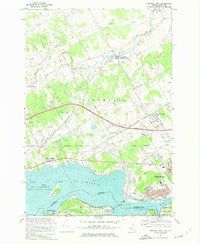
1964 Map of Cornwall West
USGS Topo · Published 1974About this map
Lake St Lawrence and the massive Moses-Saunders Dam anchor this mid-1960s borderlands survey, capturing the industrial and navigational transformation of the international boundary. The St Lawrence River corridor is defined by complex infrastructure, including the Canal and several large islands like Barnhart Island and Sheek Island. North of the border, the landscape of Ontario's Stormont County transitions from the urban street grid of Cornwall—featuring named ways such as Rosemount St and Dover St—to a rural interior dotted with numerous gravel pits and quarries. The transportation network is in a period of high development, shown through the path of the Macdonald-Cartier Freeway and the Canadian National Railroad. Local commerce and community life are marked by landmarks like a drive-in theater and the St Andrews West Post Office.
Find a feature on this map
58 named features on this map. Tap any name to fly to it.
Don’t see what you’re looking for? This feature index may not catch every label — zoom into the map to look around manually.
Map Details
Editions of this 1964 Cornwall West Map
This is the sole edition of this map. No revisions or reprints were ever made.
Other maps of this area

1906 · Massena
USGS Topo · 1:62,500

1907 · Massena
USGS Topo · 1:62,500

1915 · Moira
USGS Topo · 1:62,500

1917 · Moira
USGS Topo · 1:62,500

1942 · Barnhart Island
USGS Topo · 1:24,000

1942 · Massena
USGS Topo · 1:24,000

1943 · Barnhart Island
USGS Topo · 1:31,680
1943 · Massena
USGS Topo · 1:31,680

1944 · Moira
USGS Topo · 1:62,500
1946 · Raquette River
USGS Topo · 1:24,000