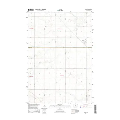
2015 Map of Corona
USGS Topo · Published 2015About this map
Corona serves as the primary hub of this eastern South Dakota landscape, positioned near the intersection of Cr-11 and Main St. The town's layout follows a traditional grid, surrounded by a vast section-line road network including 139th St and 471st Ave. This 2015 survey illustrates the enduring agricultural character of the region, where the Roberts Co and Grant Co line divides the territory. The topography is defined by the wandering path of the N Fork Whetstone River, which cuts through the northern sections of the map. This river system creates a distinct break in the otherwise regular terrestrial survey lines, providing the primary natural drainage for the surrounding prairie farmsteads.
Find a feature on this map
25 named features on this map. Tap any name to fly to it.
Don’t see what you’re looking for? This feature index may not catch every label — zoom into the map to look around manually.
Map Details
Editions of this 2015 Corona Map
This is the sole edition of this map. No revisions or reprints were ever made.
Other maps of this area

1953 · Milbank
USGS Topo · 1:250,000

1954 · Big Stone Lake
USGS Topo · 1:62,500

1958 · Milbank
USGS Topo · 1:250,000

1970 · Marvin
USGS Topo · 1:24,000

1970 · Wilmot NW
USGS Topo · 1:24,000

1971 · Corona
USGS Topo · 1:24,000

1971 · Big Stone Lake West
USGS Topo · 1:24,000

1971 · Big Stone Lake SW
USGS Topo · 1:24,000
1971 · Wilmot
USGS Topo · 1:24,000

1973 · Twin Brooks
USGS Topo · 1:24,000