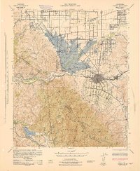
1943 Map of Corona
USGS Topo · Published 1943About this map
The Santa Ana River corridor defines this wartime landscape, dominated by the massive footprint of the Prado Dam and the surrounding Prado Flood Control Basin. At the edge of the Chino Hills, the California Institution for Men stands near the Los Serranos Country Club, marking a period of significant institutional and recreational growth in the region. The city of Corona appears as a centralized grid, served by the Santa Fe railroad and an Electric Railway, while the southern portion of the map is dominated by the steep terrain of the Santa Ana Mountains within the Cleveland National Forest. For researchers, the map captures the transition from agricultural valley floors to developed settlements like Norco and Home Gardens, before post-war suburbanization fully altered the canyon and river landscape.
Find a feature on this map
56 named features on this map. Tap any name to fly to it.
Don’t see what you’re looking for? This feature index may not catch every label — zoom into the map to look around manually.
Map Details
Editions of this 1943 Corona Map
This is the sole edition of this map. No revisions or reprints were ever made.
Other maps of this area

1894 · Pomona
USGS Topo · 1:62,500

1896 · Santa Ana
USGS Topo · 1:62,500

1896 · Anaheim
USGS Topo · 1:62,500

1896 · San Bernardino
USGS Topo · 1:62,500

1897 · Pomona
USGS Topo · 1:62,500

1897 · Cucamonga
USGS Topo · 1:62,500

1898 · Pomona
USGS Topo · 1:62,500

1898 · San Bernardino
USGS Topo · 1:62,500

1898 · Anaheim
USGS Topo · 1:62,500

1900 · Cucamonga
USGS Topo · 1:62,500