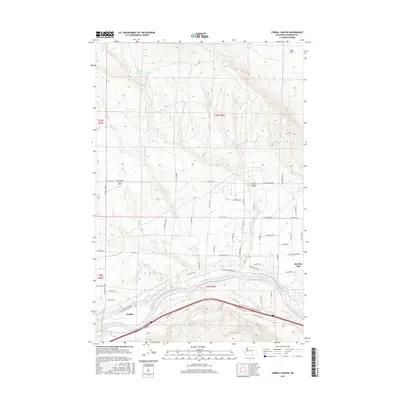
2017 Map of Corral Canyon
USGS Topo · Published 2017About this map
The Yakima River winds through the southern reaches of this landscape, flanked by the vital irrigation infrastructure of the Sunnyside Canal and Kiona Canal. This network of waterways supports the agricultural life of Benton City and the nearby settlement of Chaffee. The terrain rises sharply away from the river valley into the high, dry country of Iowa Flats and the namesake Corral Canyon.
Find a feature on this map
59 named features on this map. Tap any name to fly to it.
Don’t see what you’re looking for? This feature index may not catch every label — zoom into the map to look around manually.
Map Details
Editions of this 2017 Corral Canyon Map
This is the sole edition of this map. No revisions or reprints were ever made.
Other maps of this area

1915 · Prosser
USGS Topo · 1:125,000

1917 · Pasco
USGS Topo · 1:125,000

1917 · Prosser
USGS Topo · 1:125,000

1951 · Richland
USGS Topo · 1:62,500

1951 · Corral Canyon
USGS Topo · 1:62,500

1953 · Walla Walla
USGS Topo · 1:250,000

1958 · Walla Walla
USGS Topo · 1:250,000

1965 · Whitstran
USGS Topo · 1:62,500
1965 · Weber Canyon
USGS Topo · 1:24,000
1965 · Whitstran
USGS Topo · 1:24,000