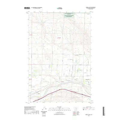
2020 Map of Corral Canyon
USGS Topo · Published 2020About this map
The Yakima River defines the southern landscape of this region, serving as the lifeblood for an extensive irrigation network near Benton City. This hydraulic engineering is visible through the intricate paths of the Kennewick Main Canal, Kiona Canal, and Sunny-side Canal, which transform the arid terrain into productive land. The transition from the river valley to the north reveals a shift toward protected wilderness and rugged uplands, notably within the Hanford Reach National Monument and the Saddle Mountain National Wildlife Refuge. Family-named landmarks like Virgil O McWhorter Spring and Katie Fleck Spring dot the higher elevations near Iowa Flats, while the small community of Chaffee sits at the junction of rail and road routes along the river's bend.
Find a feature on this map
45 named features on this map. Tap any name to fly to it.
Don’t see what you’re looking for? This feature index may not catch every label — zoom into the map to look around manually.
Map Details
Editions of this 2020 Corral Canyon Map
This is the sole edition of this map. No revisions or reprints were ever made.
Other maps of this area

1915 · Prosser
USGS Topo · 1:125,000

1917 · Pasco
USGS Topo · 1:125,000

1917 · Prosser
USGS Topo · 1:125,000

1951 · Richland
USGS Topo · 1:62,500

1951 · Corral Canyon
USGS Topo · 1:62,500

1953 · Walla Walla
USGS Topo · 1:250,000

1958 · Walla Walla
USGS Topo · 1:250,000

1965 · Whitstran
USGS Topo · 1:62,500
1965 · Weber Canyon
USGS Topo · 1:24,000
1965 · Whitstran
USGS Topo · 1:24,000