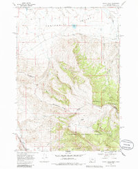
1968 Map of Corral Creek
USGS Topo · Published 1986About this map
Continental Divide crests across this 1960s survey, marking the high-altitude border between Montana and Idaho. The landscape is defined by the steep transition from the Centennial Valley in the north into the timbered slopes of the Targhee National Forest and the Centennial Mountains. In the far southwest corner, the small settlement of Humphrey sits along the Union Pacific railroad line near the banks of Beaver Creek. The drainage patterns here are complex, with the Lima Reservoir collecting headwaters in the northwest while numerous seasonal and permanent streams like Corral Creek and Long Creek carve through the mountainsides. This map captures the region when primitive roads and a lone Radio Tower were the primary indicators of modern development in an otherwise high-mountain wilderness.
Find a feature on this map
26 named features on this map. Tap any name to fly to it.
Don’t see what you’re looking for? This feature index may not catch every label — zoom into the map to look around manually.
Map Details
Editions of this 1968 Corral Creek Map
2 editions found
Other maps of this area

1955 · Dubois
USGS Topo · 1:250,000

1957 · Paul Reservoir
USGS Topo · 1:62,500

1958 · Dubois
USGS Topo · 1:250,000

1968 · Corral Creek
USGS Topo · 1:24,000

1968 · Big Table Mountain
USGS Topo · 1:24,000

1968 · Lima Dam
USGS Topo · 1:24,000

1968 · Antelope Peak
USGS Topo · 1:24,000

1968 · Monida
USGS Topo · 1:24,000
1968 · Wolverine Creek
USGS Topo · 1:24,000

1972 · Spencer North
USGS Topo · 1:24,000