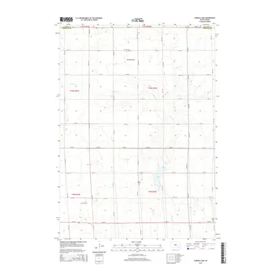
2015 Map of Corsica Lake
USGS Topo · Published 2015About this map
Blooming Valley serves as a central landmark in this South Dakota agricultural landscape, where the prairie is organized by a precise grid of rural roads and section lines. The terrain is defined by the winding course of Chateau Cr, which feeds into the prominent Corsica Lake in the southern half of the quadrangle. For those researching local family history, several burial grounds are scattered across the townships, including Saint John Cem to the north and Old Ebenezer Cem near the lake. Further south, Grandview Cem and Saint Peters Cem provide additional points of interest for genealogists tracing early residents of Douglas County. The map reflects a modern era of land management while maintaining the historical footprint of the rural communities and cemeteries that have anchored this region for generations.
Find a feature on this map
24 named features on this map. Tap any name to fly to it.
Don’t see what you’re looking for? This feature index may not catch every label — zoom into the map to look around manually.
Map Details
Editions of this 2015 Corsica Lake Map
This is the sole edition of this map. No revisions or reprints were ever made.
Other maps of this area

1899 · Mitchell
USGS Topo · 1:125,000

1955 · Mitchell
USGS Topo · 1:250,000

1959 · Mitchell
USGS Topo · 1:250,000

1979 · Delmont
USGS Topo · 1:24,000
1979 · Armour
USGS Topo · 1:24,000
1979 · Armour SW
USGS Topo · 1:24,000
1979 · Hillside
USGS Topo · 1:24,000

1980 · Stickney
USGS Topo · 1:24,000

1980 · Corsica Lake
USGS Topo · 1:24,000

1980 · Old Stickney Lake
USGS Topo · 1:24,000
Featured Places
- Grandview Township, SD
- Valley Township, SD
- Walnut Grove Township, SD
- Garfield Township, SD
- Baker Township, SD