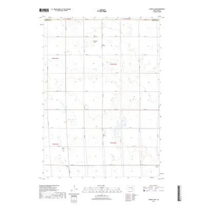
2017 Map of Corsica Lake
USGS Topo · Published 2017About this map
Blooming Valley characterizes this rural landscape in Douglas County, where the plains are defined by the winding course of Chateau Cr. The map reveals a deeply rooted agrarian community, marked by a high concentration of local burial grounds that reflect the area's early settlement history. These include the Saint John Cem, Blooming Valley Cem, Old Ebenezer Cem, Grandview Cem, and Saint Peters Cem. In the southeastern portion of the quadrangle, Corsica Lake serves as a prominent water feature amid the grid of section lines and gravel roads. This 2017 survey shows the enduring township structure, where family farms are accessed via a precise network of routes like Co HWY 560 and 394th Ave, maintaining the traditional layout established during the initial homesteading era of South Dakota.
Find a feature on this map
33 named features on this map. Tap any name to fly to it.
Don’t see what you’re looking for? This feature index may not catch every label — zoom into the map to look around manually.
Map Details
Editions of this 2017 Corsica Lake Map
This is the sole edition of this map. No revisions or reprints were ever made.
Other maps of this area

1899 · Mitchell
USGS Topo · 1:125,000

1955 · Mitchell
USGS Topo · 1:250,000

1959 · Mitchell
USGS Topo · 1:250,000

1979 · Delmont
USGS Topo · 1:24,000
1979 · Armour
USGS Topo · 1:24,000
1979 · Armour SW
USGS Topo · 1:24,000
1979 · Hillside
USGS Topo · 1:24,000

1980 · Stickney
USGS Topo · 1:24,000

1980 · Corsica Lake
USGS Topo · 1:24,000

1980 · Old Stickney Lake
USGS Topo · 1:24,000
Featured Places
- Grandview Township, SD
- Valley Township, SD
- Walnut Grove Township, SD
- Garfield Township, SD
- Baker Township, SD