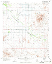
1962 Map of Cortez Peak
USGS Topo · Published 1971About this map
Centennial Farms and isolated desert outposts like Desert-Ho Ranch anchor this arid landscape within the Harquahala Mountains and the Gila Bend foothills. The region's geography is defined by a series of dry washes, most notably Centennial Wash and Fourth of July Wash, which dictate the placement of numerous wells and early desert tracks. The terrain transitions from the jagged peaks of Saddle Mountain and Cortez Peak to the flat, surveyed plains marked by the Base Line. Resource extraction is evident along the eastern mountain flanks, where the Palo Verde Mine, Dixie Mine, and Jackpot Mine indicate the mineral interests of the mid-20th century. Infrastructure including a prominent Aqueduct and Pipeline reflect the critical importance of water management in this high-desert environment during the 1960s.
Find a feature on this map
44 named features on this map. Tap any name to fly to it.
Don’t see what you’re looking for? This feature index may not catch every label — zoom into the map to look around manually.
Map Details
Editions of this 1962 Cortez Peak Map
2 editions found

Other maps of this area

1927 · Hyder
USGS Topo · 1:62,500

1930 · Hyder
USGS Topo · 1:62,500

1942 · Vicksburg
USGS Topo · 1:250,000

1951 · Dendora Valley
USGS Topo · 1:62,500

1951 · Woolsey Peak
USGS Topo · 1:62,500

1954 · Phoenix
USGS Topo · 1:250,000

1957 · Phoenix
USGS Topo · 1:250,000

1958 · Phoenix
USGS Topo · 1:250,000

1960 · Phoenix
USGS Topo · 1:250,000

1961 · Lone Mountain
USGS Topo · 1:62,500