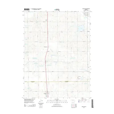
2014 Map of Cortland
USGS Topo · Published 2014About this map
Cortland and Princeton anchor this agricultural region along the border of Lancaster Co and Gage Co. The landscape is defined by an extensive network of water management projects, including Stagecoach Lake, Vergith Reservoir, and numerous numbered basins such as Upper Big Nemaha Reservoir 15-A. These reservoirs regulate the flow of the Middle Br Big Nemaha River, Indian Cr, and Salt Cr tributaries, supporting the surrounding farmsteads. The Homestead Expy serves as the primary north-south artery, connecting these small communities. Local history is preserved at the Stockfeldt Cem, Princeton Cem, and Dietz Cem, which are tucked away on sections of the rural grid. The map also captures the southern edge of Hickman via Hickman Br, illustrating how the township-and-range system organizes the prairie into a distinct pattern of roads like Pella Rd and Stagecoach Rd.
Find a feature on this map
70 named features on this map. Tap any name to fly to it.
Don’t see what you’re looking for? This feature index may not catch every label — zoom into the map to look around manually.
Map Details
Editions of this 2014 Cortland Map
This is the sole edition of this map. No revisions or reprints were ever made.
Other maps of this area

1897 · Lincoln
USGS Topo · 1:125,000

1955 · Lincoln
USGS Topo · 1:250,000

1957 · Lincoln
USGS Topo · 1:250,000

1957 · Clatonia
USGS Topo · 1:24,000

1958 · Lincoln
USGS Topo · 1:250,000

1964 · Cortland
USGS Topo · 1:24,000

1964 · Pickrell
USGS Topo · 1:24,000
1964 · Hallam
USGS Topo · 1:24,000

1964 · Denton
USGS Topo · 1:24,000

1964 · Roca
USGS Topo · 1:24,000