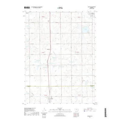
2017 Map of Cortland
USGS Topo · Published 2017About this map
Sprague and Hickman sit at the northern edge of this Nebraska landscape, where the headwaters of Salt Cr and the Hickman Br begin their courses through the rolling plains. The geography is defined by an extensive water management system, featuring numerous flood control structures such as Salt Cr Reservoir 5-A and the Upper Big Nemaha Reservoir 15-A. These reservoirs sit alongside the Middle Br Big Nemaha River, illustrating the 20th-century transformation of the local drainage basins to support agriculture and recreation at Stagecoach Lake.
Find a feature on this map
52 named features on this map. Tap any name to fly to it.
Don’t see what you’re looking for? This feature index may not catch every label — zoom into the map to look around manually.
Map Details
Editions of this 2017 Cortland Map
This is the sole edition of this map. No revisions or reprints were ever made.
Other maps of this area

1897 · Lincoln
USGS Topo · 1:125,000

1955 · Lincoln
USGS Topo · 1:250,000

1957 · Lincoln
USGS Topo · 1:250,000

1957 · Clatonia
USGS Topo · 1:24,000

1958 · Lincoln
USGS Topo · 1:250,000

1964 · Cortland
USGS Topo · 1:24,000

1964 · Pickrell
USGS Topo · 1:24,000
1964 · Hallam
USGS Topo · 1:24,000

1964 · Denton
USGS Topo · 1:24,000

1964 · Roca
USGS Topo · 1:24,000