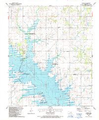
1987 Map of Corum
USGS Topo · Published 1988About this map
Waurika Lake dominates this southern Oklahoma landscape, where the waters of the Aqueduct and Walker Creek converge across the Stephens and Jefferson County line. The map captures a transition in land use, showing a vast State Wildlife Management Area surrounding the lake's fingers, while maintaining the traditional rural infrastructure of the early 20th century. Local history and genealogy interests are centered around the settlement of Corum and its associated Corum Cemetery, along with the Grandview School and Diamond Cemetery. The inclusion of the legendary Chisholm Trail and Kiowa Park No 2 suggests the deep roots of the region's ranching and travel history. Away from the water, the terrain is dotted with small-scale industry like the Shelby Landing Strip and various gravel pits, reflecting a working landscape alongside the newer recreational developments like Wichita Ridge Park.
Find a feature on this map
30 named features on this map. Tap any name to fly to it.
Don’t see what you’re looking for? This feature index may not catch every label — zoom into the map to look around manually.
Map Details
Editions of this 1987 Corum Map
This is the sole edition of this map. No revisions or reprints were ever made.
Other maps of this area

1901 · Addington
USGS Topo · 1:125,000

1955 · Lawton
USGS Topo · 1:250,000

1957 · Hastings
USGS Topo · 1:62,500

1957 · Ardmore
USGS Topo · 1:250,000

1962 · Ryan
USGS Topo · 1:62,500

1962 · Temple
USGS Topo · 1:62,500

1963 · Ardmore
USGS Topo · 1:250,000

1964 · Duncan South
USGS Topo · 1:24,000

1964 · Comanche
USGS Topo · 1:24,000

1984 · Hooper
USGS Topo · 1:24,000