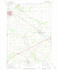
1972 Map of Corunna
USGS Topo · Published 1975About this map
The Shiawassee River winds through the heart of this central Michigan landscape, anchoring a series of small 1970s communities and agricultural townships. In the north, Corunna serves as the county's hub, featuring its historic Courthouse and Po near the bend of the river. The region is marked by its industrial and extraction history, with evidence of a Strip Mine and Coal Mine along Strip Mine Road north of town, alongside several Gravel Pits that dot the countryside.
Find a feature on this map
61 named features on this map. Tap any name to fly to it.
Don’t see what you’re looking for? This feature index may not catch every label — zoom into the map to look around manually.
Map Details
Editions of this 1972 Corunna Map
This is the sole edition of this map. No revisions or reprints were ever made.
Other maps of this area

1917 · Chesaning
USGS Topo · 1:62,500

1919 · Burt
USGS Topo · 1:62,500

1921 · Burt
USGS Topo · 1:62,500

1922 · Durand
USGS Topo · 1:62,500

1926 · Corunna
USGS Topo · 1:62,500

1929 · Corunna
USGS Topo · 1:62,500

1943 · Burt
USGS Topo · 1:62,500

1943 · Chesaning
USGS Topo · 1:62,500

1943 · Durand
USGS Topo · 1:62,500

1944 · Corunna
USGS Topo · 1:62,500