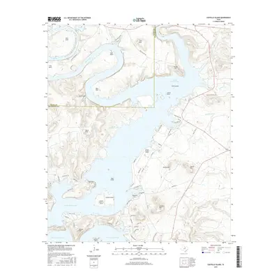
2016 Map of Costello Island
USGS Topo · Published 2016About this map
Possum Kingdom Lake dominates this Palo Pinto County landscape, where the Brazos River creates a series of dramatic meanders including Ming Bend, Waco Bend, and Gaines Bend. The topography is defined by significant elevations such as McAdams Peak, Gordon Mtn, and Bald Mtn, rising above the reservoir's convoluted shoreline. The map documents modern infrastructure alongside historical markers, featuring the Possum Kingdom Airport and the smaller Costello Island, Inc Airport on Costello Island. Genealogists and local historians can locate the McAdams Cem near McGinnis Point, while several named sloughs and creeks like Chimney Slough and Deep Elm Cr drain the surrounding heights. The area is intersected by a network of local routes including FM 2353 and Park Rd 36, which serve the various residential developments and camps along the lake.
Find a feature on this map
74 named features on this map. Tap any name to fly to it.
Don’t see what you’re looking for? This feature index may not catch every label — zoom into the map to look around manually.
Map Details
Editions of this 2016 Costello Island Map
This is the sole edition of this map. No revisions or reprints were ever made.
Other maps of this area

1890 · Breckenridge
USGS Topo · 1:125,000

1891 · Palo Pinto
USGS Topo · 1:125,000

1918 · Palo Pinto
USGS Topo · 1:125,000

1924 · Breckenridge 1-a
USGS Topo · 1:48,000

1924 · Palo Pinto 2-b
USGS Topo · 1:48,000

1924 · Palo Pinto 2-a
USGS Topo · 1:48,000

1924 · Graham 4-d
USGS Topo · 1:48,000

1924 · Palo Pinto 2-c
USGS Topo · 1:48,000

1924 · Breckenridge 1-d
USGS Topo · 1:48,000

1927 · Graham
USGS Topo · 1:62,500