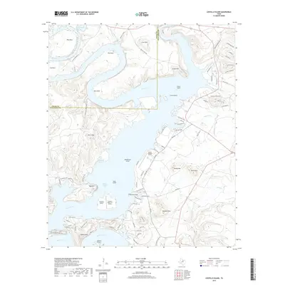
2019 Map of Costello Island
USGS Topo · Published 2019About this map
Possum Kingdom Lake dominates this portion of the Brazos River where the water snakes around dramatic peninsulas and high points. This 2019 survey captures the developed shoreline and recreational landscape of Costello Island and the surrounding peaks. The topography is defined by sharp elevation changes, notably at McAdams Peak, Johnson Peak, and Bald Mtn, which overlook the complex network of sloughs and bends. The presence of both the Possum Kingdom Airport and the Costello Island, Inc Airport underscores the area's role as a regional destination. Cultural markers like the McAdams Cem near McGinnis Point offer a connection to the area's earlier history before the reservoir's expansion. The road network, including Park Rd 36 and numerous local loops like Johnson Peak Loop, illustrates the modern residential and recreational infrastructure that has integrated into the river’s ancient meanders like Wild Bend and Ming Bend.
Find a feature on this map
91 named features on this map. Tap any name to fly to it.
Don’t see what you’re looking for? This feature index may not catch every label — zoom into the map to look around manually.
Map Details
Editions of this 2019 Costello Island Map
This is the sole edition of this map. No revisions or reprints were ever made.
Other maps of this area

1890 · Breckenridge
USGS Topo · 1:125,000

1891 · Palo Pinto
USGS Topo · 1:125,000

1918 · Palo Pinto
USGS Topo · 1:125,000

1924 · Breckenridge 1-a
USGS Topo · 1:48,000

1924 · Palo Pinto 2-b
USGS Topo · 1:48,000

1924 · Palo Pinto 2-a
USGS Topo · 1:48,000

1924 · Graham 4-d
USGS Topo · 1:48,000

1924 · Palo Pinto 2-c
USGS Topo · 1:48,000

1924 · Breckenridge 1-d
USGS Topo · 1:48,000

1927 · Graham
USGS Topo · 1:62,500