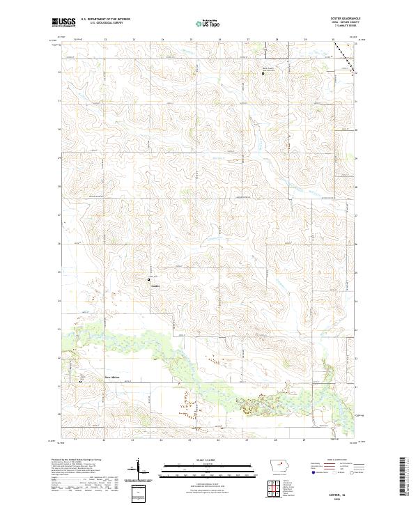
2022 Map of Coster
USGS Topo · Published 2022About this map
West Fork Cedar River carves a wide, complex floodplain across the southern half of this landscape, characterized by numerous oxbows and marshy lowlands. The rural settlement of Coster serves as a central point in a grid of section roads, including Quail Ave and 255th St. This area of Butler County shows a long-standing reliance on its river systems and agricultural land divisions, with small hamlets like New Albion situated near the riverbanks. The mapping of Butler County Poor Farm Cem in the north provides a poignant link to the county's social history and the care of its indigent residents during earlier eras. Higher ground between the drainage of McClure Creek and Landphere Cr is marked by a precise network of limestone-named roads like Quarry Ave, reflecting the local geological resources that likely supported the area's development.
Find a feature on this map
43 named features on this map. Tap any name to fly to it.
Don’t see what you’re looking for? This feature index may not catch every label — zoom into the map to look around manually.
Map Details
Editions of this 2022 Coster Map
This is the sole edition of this map. No revisions or reprints were ever made.
Other maps of this area

1954 · Waterloo
USGS Topo · 1:250,000

1955 · Waterloo
USGS Topo · 1:250,000

1971 · Shell Rock
USGS Topo · 1:24,000

1971 · Coster
USGS Topo · 1:24,000

1971 · Plainfield
USGS Topo · 1:24,000

1971 · Clarksville
USGS Topo · 1:24,000

1971 · Stout
USGS Topo · 1:24,000
1971 · New Hartford
USGS Topo · 1:24,000

1972 · Allison
USGS Topo · 1:24,000

1979 · Butler Center
USGS Topo · 1:24,000