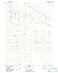
1960 Map of Cottier
USGS Topo · Published 1993About this map
The North Platte River carves through this Goshen County landscape, serving as a primary corridor for both historic westward expansion and mid-20th-century irrigation. The route of the Emigrant Trail parallels the river, marked by local landmarks like the Rock Ranch (Historical) and a Historical Mon. These early transit paths were eventually supplemented by a complex water management system, including the Fort Laramie Canal, Emigrant Ditch, and Rock Ranch Canal, which transformed the flatlands into productive agricultural terrain.
Find a feature on this map
28 named features on this map. Tap any name to fly to it.
Don’t see what you’re looking for? This feature index may not catch every label — zoom into the map to look around manually.
Map Details
Editions of this 1960 Cottier Map
3 editions found
Other maps of this area

1896 · Patrick
USGS Topo · 1:125,000

1899 · Goshen Hole
USGS Topo · 1:125,000

1954 · Torrington
USGS Topo · 1:250,000

1954 · Cheyenne
USGS Topo · 1:250,000

1958 · Cheyenne
USGS Topo · 1:250,000

1958 · Torrington
USGS Topo · 1:250,000

1960 · Habig Spring
USGS Topo · 1:24,000

1960 · Huntley
USGS Topo · 1:24,000

1960 · Veteran
USGS Topo · 1:24,000
1960 · Barnes
USGS Topo · 1:24,000