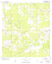
1954 Map of Cotton Plant
USGS Topo · Published 1977About this map
Cotton Plant and its surrounding rural hamlets are captured here during a period defined by phosphate mining and railroad transit in Marion County. The landscape is dotted with numerous small bodies of water and wet depressions, such as Hog Pond, Carter Pond, and the expansive Sturgis Prairie. This mid-century survey documents the spatial relationship between small agricultural communities and the heavy industry of the era, evidenced by a Mine near Early Bird and multiple Gravel Pits concentrated around the settlement of York.
Find a feature on this map
30 named features on this map. Tap any name to fly to it.
Don’t see what you’re looking for? This feature index may not catch every label — zoom into the map to look around manually.
Map Details
Editions of this 1954 Cotton Plant Map
2 editions found
Other maps of this area

1892 · Dunnellon
USGS Topo · 1:62,500

1893 · Citra
USGS Topo · 1:62,500

1894 · Dunnellon
USGS Topo · 1:62,500

1895 · Williston
USGS Topo · 1:62,500

1895 · Citra
USGS Topo · 1:62,500

1895 · Ocala
USGS Topo · 1:62,500

1954 · Romeo
USGS Topo · 1:24,000

1954 · Dunnellon
USGS Topo · 1:24,000

1954 · Cotton Plant
USGS Topo · 1:24,000

1954 · Dunnellon SE
USGS Topo · 1:24,000