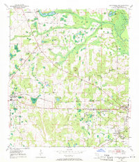
1952 Map of Cottondale East
USGS Topo · Published 1971About this map
Marianna and Cottondale serve as the primary hubs in this Jackson County landscape, surveyed in the early 1950s. The region is defined by a dense network of karst topography, evident in the numerous named sinkhole ponds such as Gnat Hole Pond, Bonnet Pond, and McNealy Pond that dot the terrain between the Chipola River and Russ Mill Creek. This area was a critical junction for regional transportation and social infrastructure, featuring the Louisville and Nashville railroad line and the Old Spanish Trail.
Find a feature on this map
49 named features on this map. Tap any name to fly to it.
Don’t see what you’re looking for? This feature index may not catch every label — zoom into the map to look around manually.
Map Details
Editions of this 1952 Cottondale East Map
2 editions found
Other maps of this area

1952 · Oakdale
USGS Topo · 1:24,000

1952 · Kynesville
USGS Topo · 1:24,000

1952 · Cottondale East
USGS Topo · 1:24,000

1952 · Malone
USGS Topo · 1:24,000

1952 · Campbellton
USGS Topo · 1:24,000

1952 · Cottondale West
USGS Topo · 1:24,000

1952 · Sills
USGS Topo · 1:24,000
1952 · Alford
USGS Topo · 1:24,000

1952 · Marianna
USGS Topo · 1:24,000

1954 · Tallahassee
USGS Topo · 1:250,000