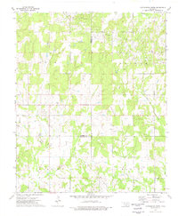
1974 Map of Cottonwood Creek
USGS Topo · Published 1977About this map
Oil and gas exploration define the landscape of south-central Oklahoma as it appeared in the mid-1970s. The map illustrates a region heavily shaped by energy production, dominated by the Loco Field and the Graham Hewitt Field, where a dense network of Oil Wells and a Refinery operate alongside rural homesteads. This industrial activity is concentrated near the intersection of the Carter, Stephens, and Jefferson County lines, showing how late-century resource extraction integrated into the traditional ranching and farming lands of the Chickasaw Nation area.
Find a feature on this map
16 named features on this map. Tap any name to fly to it.
Don’t see what you’re looking for? This feature index may not catch every label — zoom into the map to look around manually.
Map Details
Editions of this 1974 Cottonwood Creek Map
This is the sole edition of this map. No revisions or reprints were ever made.
Other maps of this area

1901 · Addington
USGS Topo · 1:125,000

1901 · Ardmore
USGS Topo · 1:125,000

1918 · Ardmore
USGS Topo · 1:125,000

1957 · Ardmore
USGS Topo · 1:250,000

1963 · Ardmore
USGS Topo · 1:250,000

1969 · Healdton
USGS Topo · 1:24,000
1969 · Tatums
USGS Topo · 1:24,000
1969 · Fox
USGS Topo · 1:24,000

1974 · Ringling NW
USGS Topo · 1:24,000

1974 · Loco
USGS Topo · 1:24,000