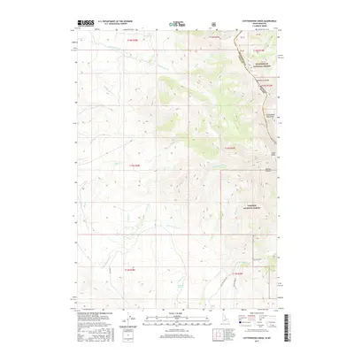
2017 Map of Cottonwood Creek
USGS Topo · Published 2017About this map
The Continental Divide forms a jagged natural boundary across this portion of the Beaverhead Mountains, separating the high crests of the Beaverhead National Forest in Montana from the Targhee National Forest in Idaho. This high-altitude drainage basin is defined by steep ravines and seasonal water sources like Walters Spring and Breazeale Spring, which feed into the wider Lemhi Valley. Primitive transportation routes such as 18 Mile Rd and Willow Creek Rd navigate the difficult terrain, connecting remote mountain passes with the lowlands. The complex hydrology of the area is mapped through numerous descending tributaries, including Eighteenmile Creek, McGinty Creek, and the namesake Cottonwood Creek, providing a detailed look at the water-carved geography that has historically dictated access through these mountain ranges.
Find a feature on this map
39 named features on this map. Tap any name to fly to it.
Don’t see what you’re looking for? This feature index may not catch every label — zoom into the map to look around manually.
Map Details
Editions of this 2017 Cottonwood Creek Map
This is the sole edition of this map. No revisions or reprints were ever made.
Other maps of this area

1955 · Dubois
USGS Topo · 1:250,000

1956 · Morrison Lake
USGS Topo · 1:62,500

1956 · Nicholia
USGS Topo · 1:62,500

1957 · Scott Peak
USGS Topo · 1:62,500

1958 · Dubois
USGS Topo · 1:250,000

1965 · Island Butte
USGS Topo · 1:24,000

1980 · Leadore
USGS Topo · 1:100,000

1983 · Dubois
USGS Topo · 1:100,000
1987 · Eighteenmile Peak
USGS Topo · 1:24,000
1987 · Morrison Lake
USGS Topo · 1:24,000