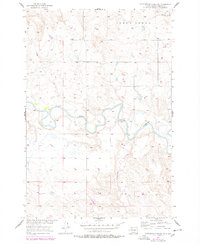
1956 Map of Cottonwood Creek NE
USGS Topo · Published 1978About this map
The Grand River meanders across this landscape within the boundaries of the Standing Rock Indian Reservation. This 1956 survey, updated with 1975 revisions, captures the hydrology of the Missouri River Basin development era. The winding path of the river is flanked by the drainage of Lodge Creek to the north and the namesake Cottonwood Creek to the south. The terrain is characterized by a sparse, open settlement pattern typical of the South Dakota plains, where natural waterways like the Grand River dictated the placement of early routes and grazing lands. Genealogists and historians can trace the topography as it existed prior to later-century landscape alterations, observing the intricate drainage networks that defined Corson County ranching country.
Find a feature on this map
3 named features on this map. Tap any name to fly to it.
Don’t see what you’re looking for? This feature index may not catch every label — zoom into the map to look around manually.
Map Details
Editions of this 1956 Cottonwood Creek NE Map
2 editions found
Other maps of this area

1953 · McIntosh
USGS Topo · 1:250,000

1956 · Black Horse SW
USGS Topo · 1:24,000

1956 · Cottonwood Creek NE
USGS Topo · 1:24,000

1956 · Black Horse
USGS Topo · 1:24,000

1956 · Cottonwood Creek SE
USGS Topo · 1:24,000

1956 · Cottonwood Creek NW
USGS Topo · 1:24,000

1956 · Cottonwood Creek SW
USGS Topo · 1:24,000

1958 · McIntosh
USGS Topo · 1:250,000

1972 · McIntosh SW
USGS Topo · 1:24,000

1972 · Morristown SE
USGS Topo · 1:24,000