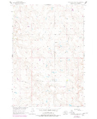
1956 Map of Cottonwood Creek SW
USGS Topo · Published 1978About this map
Archambault Creek and Black Horse Butte Creek define the drainage patterns of this prairie landscape within the Standing Rock Indian Reservation. This 1950s survey, updated with late 1970s photogrammetry, reveals a sparsely populated ranching and mining area. Rural education and local industry are marked by the Gopher Sch and a Strip Mine located along an unnamed drainage. The presence of Berry Dam in the north highlights the importance of water management in this arid region, while the network of creeks like Meadow Creek suggests a terrain shaped by seasonal water flow across the Missouri River Basin.
Find a feature on this map
6 named features on this map. Tap any name to fly to it.
Don’t see what you’re looking for? This feature index may not catch every label — zoom into the map to look around manually.
Map Details
Editions of this 1956 Cottonwood Creek SW Map
2 editions found
Other maps of this area

1953 · McIntosh
USGS Topo · 1:250,000

1956 · Cottonwood Creek NE
USGS Topo · 1:24,000

1956 · Cottonwood Creek SE
USGS Topo · 1:24,000

1956 · Cottonwood Creek NW
USGS Topo · 1:24,000

1956 · Cottonwood Creek SW
USGS Topo · 1:24,000

1958 · McIntosh
USGS Topo · 1:250,000

1972 · Twin Butte
USGS Topo · 1:24,000

1972 · Black Horse Butte NE
USGS Topo · 1:24,000

1980 · McIntosh
USGS Topo · 1:100,000

1982 · Glad Valley
USGS Topo · 1:24,000