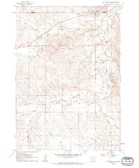
1961 Map of Cottonwood NE
USGS Topo · Published 1963About this map
The Chicago and North Western railroad cuts across the northern landscape of Jackson and Haakon counties, following the drainage of Dry Creek and Cottonwood Creek. This 1961 field-checked survey reveals a sparsely settled ranching environment where the South Fork Bad River meanders eastward through the center of the map. Educational life is represented by the isolated Fairview Sch in the southwest quadrant, while the small Landing Strip near the railroad tracks indicates the importance of aerial access in this expansive terrain. To the south, the headwaters of Big Buffalo Creek, Little Buffalo Creek, and Whitewater Creek define the topography, with significant natural features like Big Buffalo and Little Buffalo marking the land. Several Gravel Pit locations along the river and various Gravel Pits to the north reflect local extraction activity during the early 1960s.
Find a feature on this map
18 named features on this map. Tap any name to fly to it.
Don’t see what you’re looking for? This feature index may not catch every label — zoom into the map to look around manually.
Map Details
Editions of this 1961 Cottonwood NE Map
2 editions found
Other maps of this area

1950 · Weta
USGS Topo · 1:24,000

1953 · Philip Junction
USGS Topo · 1:24,000

1953 · Philip
USGS Topo · 1:24,000

1954 · Pierre
USGS Topo · 1:250,000

1955 · Martin
USGS Topo · 1:250,000

1958 · Pierre
USGS Topo · 1:250,000

1958 · Martin
USGS Topo · 1:250,000

1960 · Cottonwood SW
USGS Topo · 1:24,000

1961 · Cottonwood
USGS Topo · 1:24,000

1961 · Cottonwood NE
USGS Topo · 1:24,000