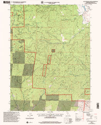
2001 Map of Cottonwood Peak
USGS Topo · Published 2004About this map
Klamath National Forest serves as the backdrop for this northern California landscape, defined by a dense network of mining claims and rugged gulches. Historically significant sites such as the Last Chance Mine, Wiegel Mine, and Cinnabar Mine are scattered across the terrain, reflecting the area's extraction history. These workings are interspersed with dozens of steep drainages like Yonka Gulch and Devils Gulch, which feed into larger water systems including Beaver Creek and the South Fork Cottonwood Creek.
Find a feature on this map
52 named features on this map. Tap any name to fly to it.
Don’t see what you’re looking for? This feature index may not catch every label — zoom into the map to look around manually.
Map Details
Editions of this 2001 Cottonwood Peak Map
This is the sole edition of this map. No revisions or reprints were ever made.
Other maps of this area

1886 · Shasta
USGS Topo · 1:250,000

1891 · Ashland
USGS Topo · 1:250,000

1893 · Ashland
USGS Topo · 1:250,000

1894 · Shasta
USGS Topo · 1:250,000

1897 · Ashland
USGS Topo · 1:250,000

1932 · Yreka
USGS Topo · 1:96,000

1938 · Medford
USGS Topo · 1:125,000

1939 · Yreka
USGS Topo · 1:125,000

1948 · Weed
USGS Topo · 1:250,000

1950 · Weed
USGS Topo · 1:250,000