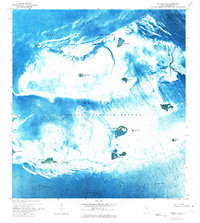
1972 Map of Cottrell Key
USGS Topo · Published 1973About this map
Key West National Wildlife Refuge encompasses nearly the entire maritime landscape of this 1970s orthophotomap, where isolated islands rise from the shallow waters between the Gulf of Mexico and the Straits of Florida. This specialized survey, compiled by the Geological Survey and the USC&GS, utilizes aerial photography to reveal the intricate topography of mangrove keys and tidal flats. From Cottrell Key in the north to the southern cluster of Woman Key, Man Key, and Boca Grande Key, the map details a delicate ecosystem defined by water depth and navigation channels. The presence of the Northwest Channel and the Intracoastal Waterway highlights the importance of this area for coastal transit even as it remained a protected wilderness. Smaller features like Joe Ingram Key, Crawfish Key, and Ballast Key serve as distinct landmarks for researchers and maritime historians studying the Lower Keys before modern environmental shifts.
Find a feature on this map
16 named features on this map. Tap any name to fly to it.
Don’t see what you’re looking for? This feature index may not catch every label — zoom into the map to look around manually.
Map Details
Editions of this 1972 Cottrell Key Map
This is the sole edition of this map. No revisions or reprints were ever made.
Other maps of this area

1921 · Key West
USGS Topo · 1:62,500

1943 · Bay Keys
USGS Topo · 1:24,000

1943 · Key West
USGS Topo · 1:24,000

1943 · Cottrell Key
USGS Topo · 1:24,000

1962 · Key West
USGS Topo · 1:24,000

1963 · Cottrell Key
USGS Topo · 1:24,000

1971 · Key West
USGS Topo · 1:24,000
1971 · Marquesas Keys East
USGS Topo · 1:24,000
1972 · Bay Keys
USGS Topo · 1:24,000

1983 · Dry Tortugas
USGS Topo · 1:100,000