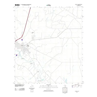
2010 Map of Cotulla
USGS Topo · Published 2010About this map
Cotulla serves as the focal point of this La Salle County study, positioned alongside the winding Nueces River. The landscape is defined by its water management systems, including several named dams and reservoirs like Cohenour Reservoir Dam and Allerkamp Reservoir, which indicate the critical importance of water storage in this semi-arid South Texas region. The town's layout is meticulously detailed, showing the street grid from Guadalupe St down to the residential expansion of Zamora Acres Colonia. Beyond the settlement, the map reveals a network of rural routes such as Ranch Rd 624 and Dobie Rd that connect outlying ranching lands. This 2010 edition also captures modern infrastructure, notably the Cotulla-La Salle County Airport, providing a clear look at the intersection of traditional river-based settlement and contemporary transportation requirements.
Find a feature on this map
22 named features on this map. Tap any name to fly to it.
Don’t see what you’re looking for? This feature index may not catch every label — zoom into the map to look around manually.
Map Details
Editions of this 2010 Cotulla Map
This is the sole edition of this map. No revisions or reprints were ever made.
Other maps of this area

1927 · Bart
USGS Topo · 1:62,500

1929 · Cotulla
USGS Topo · 1:125,000

1940 · Cotulla
USGS Topo · 1:62,500

1940 · Artesia Wells
USGS Topo · 1:62,500

1942 · Dilley
USGS Topo · 1:62,500

1953 · Crystal City
USGS Topo · 1:250,000

1955 · Crystal City
USGS Topo · 1:250,000

1956 · Woodward
USGS Topo · 1:62,500

1961 · Crystal City
USGS Topo · 1:250,000

1968 · Crystal City
USGS Topo · 1:250,000