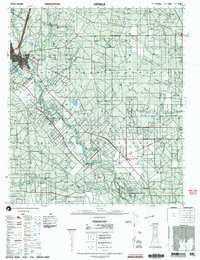
2002 Map of Cotulla
USGS Topo · Published 2002About this map
Cotulla serves as the primary hub of this South Texas landscape, situated along the north bank of the Nueces River. The terrain is defined by a dendritic network of seasonal drainages, including Mustang Creek, Charco Marrano Creek, and Las Raices Creek, which cross a landscape marked by ranching and resource extraction. Transportation infrastructure is prominent, with the Cotulla-LaSalle County Airport and various radio facilities supporting the regional center. To the east, the small settlement of Los Angeles sits at a crossroads, while the presence of a Gravel Pit and Mine suggest the active mineral interests of the early 21st century. The map provides a clear view of the rural property divisions and water management features, such as tanks and wells, that sustain life in this semi-arid region of La Salle County.
Find a feature on this map
14 named features on this map. Tap any name to fly to it.
Don’t see what you’re looking for? This feature index may not catch every label — zoom into the map to look around manually.
Map Details
Editions of this 2002 Cotulla Map
This is the sole edition of this map. No revisions or reprints were ever made.
Other maps of this area

1927 · Bart
USGS Topo · 1:62,500

1929 · Cotulla
USGS Topo · 1:125,000

1940 · Cotulla
USGS Topo · 1:62,500

1940 · Artesia Wells
USGS Topo · 1:62,500

1942 · Fowlerton
USGS Topo · 1:62,500

1942 · Dilley
USGS Topo · 1:62,500

1953 · Crystal City
USGS Topo · 1:250,000

1955 · Crystal City
USGS Topo · 1:250,000

1956 · Woodward
USGS Topo · 1:62,500

1956 · Piedra Creek
USGS Topo · 1:62,500