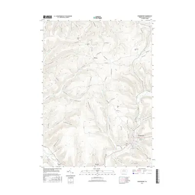
2016 Map of Coudersport
USGS Topo · Published 2016About this map
Coudersport occupies the lower right quadrant of this survey, situated at the confluence of several vital waterways including Mill Cr and the Allegheny River. The landscape is defined by a dense network of named hollows and hills that influenced the layout of early rural roads. To the south, Olmsted sits near the Saint Eulalias Cem, while the northern reaches include the settlement of Hebron and high points like Negro Hill and Crandal Hill. The terrain dictates a complex drainage pattern where Dingman Run and Whitney Cr cut through the high ground. Local transit and infrastructure are evidenced by the Ranch Aero Airport and several ridge-top thoroughfares like Maple Ridge Rd. This 2016 record reflects a classic Appalachian valley settlement pattern where town development is tightly constrained by the surrounding steep hollows, such as Kavanaugh Hollow and Hogpen Hollow.
Find a feature on this map
77 named features on this map. Tap any name to fly to it.
Don’t see what you’re looking for? This feature index may not catch every label — zoom into the map to look around manually.
Map Details
Editions of this 2016 Coudersport Map
This is the sole edition of this map. No revisions or reprints were ever made.
Other maps of this area

1932 · Genesee
USGS Topo · 1:62,500

1934 · Coudersport
USGS Topo · 1:48,000

1937 · Genesee
USGS Topo · 1:62,500

1938 · Coudersport
USGS Topo · 1:62,500

1947 · Conrad
USGS Topo · 1:62,500

1947 · Ayers Hill
USGS Topo · 1:24,000

1948 · Emporium
USGS Topo · 1:62,500

1948 · Keating Summit
USGS Topo · 1:24,000
1948 · Austin
USGS Topo · 1:24,000
1949 · Ayers Hill
USGS Topo · 1:24,000
Featured Places
- Roulette Township, PA
- Hebron Township, PA
- Clara Township, PA
- Olmsted, Eulalia Township
- Eulalia Township, PA