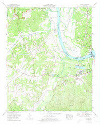
1972 Map of Counce
USGS Topo · Published 1974About this map
Shiloh National Military Park occupies the northwestern corner of this study, where the Confederate Restricted Road and Bark Road mark the grounds of the 1862 battlefield. This 1970s revision shows the riverine landscape of the Tennessee River dominated by the massive Pickwick Landing Dam and the sprawling waters of Kentucky Lake. The intersection of modern infrastructure and rural history is evident near Counce, where a Dragstrip and Switchyard operate alongside family-named landmarks like Beshars Cem and Taylor Cem.
Find a feature on this map
63 named features on this map. Tap any name to fly to it.
Don’t see what you’re looking for? This feature index may not catch every label — zoom into the map to look around manually.
Map Details
Editions of this 1972 Counce Map
3 editions found
Other maps of this area

1911 · Iuka
USGS Topo · 1:48,000

1914 · Iuka
USGS Topo · 1:62,500

1935 · Doskie
USGS Topo · 1:24,000

1936 · Savannah
USGS Topo · 1:24,000

1936 · Counce
USGS Topo · 1:24,000

1936 · Kendrick
USGS Topo · 1:24,000

1936 · Shaws
USGS Topo · 1:24,000

1936 · Pickwick
USGS Topo · 1:24,000

1936 · Pittsburg Landing
USGS Topo · 1:24,000

1936 · Stantonville
USGS Topo · 1:24,000