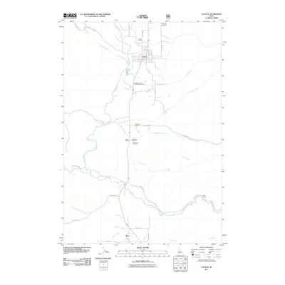
2011 Map of Council
USGS Topo · Published 2011About this map
Council serves as the focal point of this 2011 survey, situated at the confluence of several vital watercourses including the Weiser River and Hornet Creek. The landscape transitions from the river valley floor toward the eastern highlands of Long Gulch and Grossen Canyon, with the Middle Fork Weiser River carving a path through the southern reaches. This area in Adams County reflects a rural identity anchored by small settlements and established civic landmarks.
Find a feature on this map
31 named features on this map. Tap any name to fly to it.
Don’t see what you’re looking for? This feature index may not catch every label — zoom into the map to look around manually.
Map Details
Editions of this 2011 Council Map
This is the sole edition of this map. No revisions or reprints were ever made.
Other maps of this area

1911 · Meadows
USGS Topo · 1:125,000

1954 · Council
USGS Topo · 1:62,500

1954 · New Meadows
USGS Topo · 1:62,500

1955 · Baker
USGS Topo · 1:250,000

1957 · Cambridge
USGS Topo · 1:62,500

1957 · Hornet
USGS Topo · 1:62,500

1959 · Baker
USGS Topo · 1:250,000

1980 · McCall
USGS Topo · 1:100,000

1986 · Peck Mountain
USGS Topo · 1:24,000
1986 · Council Mountain
USGS Topo · 1:24,000