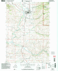
2004 Map of Council
USGS Topo · Published 2007About this map
The Council valley and its surrounding highlands are documented here during a period of transition in the early 2000s. The township serves as a central hub for the region, anchored by the Council Municipal Airport, a local Hospital, and the county Fairground. To the south, the settlement at Mesa and the nearby Mesa Siding reflect the historical importance of transportation and agriculture in the area. The Weiser River and the Middle Fork Weiser River define the local drainage, carving through the terrain near Hornet Ridge.
Find a feature on this map
27 named features on this map. Tap any name to fly to it.
Don’t see what you’re looking for? This feature index may not catch every label — zoom into the map to look around manually.
Map Details
Editions of this 2004 Council Map
This is the sole edition of this map. No revisions or reprints were ever made.
Other maps of this area

1911 · Meadows
USGS Topo · 1:125,000

1954 · Council
USGS Topo · 1:62,500

1954 · New Meadows
USGS Topo · 1:62,500

1955 · Baker
USGS Topo · 1:250,000

1957 · Cambridge
USGS Topo · 1:62,500

1957 · Hornet
USGS Topo · 1:62,500

1959 · Baker
USGS Topo · 1:250,000

1980 · McCall
USGS Topo · 1:100,000

1986 · Peck Mountain
USGS Topo · 1:24,000
1986 · Council Mountain
USGS Topo · 1:24,000