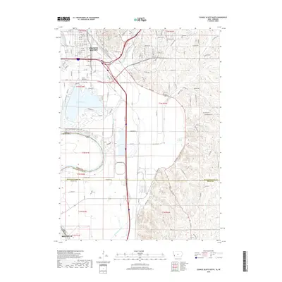
2018 Map of Council Bluffs South
USGS Topo · Published 2018About this map
Council Bluffs occupies the northern reaches of this Missouri River corridor, where urban street grids meet the sprawling wetlands and floodplains of Lake Manawa State Park. The landscape is defined by extensive water management, including the Indian Cr Ditch, Mosquito Creek, and Saint Marys Ditch, which redirect water through the low-lying valley. Transport infrastructure is prominent, with the BNSF Railway and a dense network of numbered avenues like 24th Ave and 30th Ave serving the city's southward expansion. Genealogy researchers can find several burial grounds south of the main settlement, including Lewis Township Cem and Saint Marys Cem. Farther south, the transition from urban to agricultural use is marked by the Pottawattamie and Mills County line, where family-named features like Plumer Cr and Plumer Cem appear among the bluffs.
Find a feature on this map
80 named features on this map. Tap any name to fly to it.
Don’t see what you’re looking for? This feature index may not catch every label — zoom into the map to look around manually.
Map Details
Editions of this 2018 Council Bluffs South Map
This is the sole edition of this map. No revisions or reprints were ever made.
Other maps of this area

1893 · Omaha
USGS Topo · 1:62,500

1954 · Omaha
USGS Topo · 1:250,000

1956 · Glenwood
USGS Topo · 1:24,000

1956 · Mineola
USGS Topo · 1:24,000

1956 · Plattsmouth
USGS Topo · 1:24,000

1956 · Council Bluffs North
USGS Topo · 1:24,000

1956 · Pacific Junction
USGS Topo · 1:24,000

1956 · Omaha North
USGS Topo · 1:24,000

1956 · Mc Clelland
USGS Topo · 1:24,000

1956 · Council Bluffs South
USGS Topo · 1:24,000