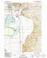
1994 Map of Council Bluffs South
USGS Topo · Published 1994About this map
Lake Manawa and the surrounding wetlands of Lake Manawa State Park dominate the landscape just south of Council Bluffs in this mid-1990s survey. The map details a complex interface between water and infrastructure where the Missouri River forms the state boundary with Nebraska. The industrial and educational character of the region is evident through the presence of a Power Plant, a Tank Farm, and specialized institutions like the Iowa School for the Deaf.
Find a feature on this map
35 named features on this map. Tap any name to fly to it.
Don’t see what you’re looking for? This feature index may not catch every label — zoom into the map to look around manually.
Map Details
Editions of this 1994 Council Bluffs South Map
This is the sole edition of this map. No revisions or reprints were ever made.
Other maps of this area

1893 · Omaha
USGS Topo · 1:62,500

1954 · Omaha
USGS Topo · 1:250,000

1956 · Glenwood
USGS Topo · 1:24,000

1956 · Mineola
USGS Topo · 1:24,000

1956 · Plattsmouth
USGS Topo · 1:24,000

1956 · Council Bluffs North
USGS Topo · 1:24,000

1956 · Pacific Junction
USGS Topo · 1:24,000

1956 · Omaha North
USGS Topo · 1:24,000

1956 · Mc Clelland
USGS Topo · 1:24,000

1956 · Council Bluffs South
USGS Topo · 1:24,000