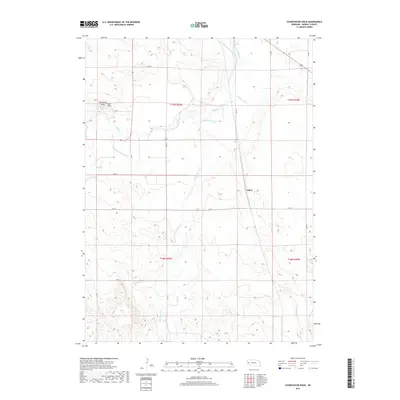
2017 Map of Courthouse Rock
USGS Topo · Published 2017About this map
Courthouse Rock and Jail Rock rise as prominent landmarks in this section of Morrill County, serving as enduring navigational beacons in the Platte River Valley landscape. The settlement of Alden sits along the eastern edge of the quadrangle, situated near a complex network of waterways that define the local agricultural economy. The importance of water management is evident in the numerous irrigation projects crisscrossing the terrain, including the Belmont Canal, Last Chance Canal, and the Meredith-Ammer Canal. These human-made features run parallel to natural drainages like Pumpkin Cr and Greenwood Cr, illustrating the intensive modification of the high plains to support regional farming. In the southern reaches, the winding path of Deep Holes Cr cuts through the topography, while a grid of rural routes such as RD 80 and RD 78 provides access to the dispersed farmsteads of the panhandle.
Find a feature on this map
25 named features on this map. Tap any name to fly to it.
Don’t see what you’re looking for? This feature index may not catch every label — zoom into the map to look around manually.
Map Details
Editions of this 2017 Courthouse Rock Map
This is the sole edition of this map. No revisions or reprints were ever made.
Other maps of this area

1896 · Browns Creek
USGS Topo · 1:125,000

1898 · Camp Clarke
USGS Topo · 1:125,000

1899 · Browns Creek
USGS Topo · 1:125,000

1899 · Sidney
USGS Topo · 1:125,000

1954 · Scottsbluff
USGS Topo · 1:250,000

1958 · Scottsbluff
USGS Topo · 1:250,000

1965 · Bridgeport NW
USGS Topo · 1:24,000

1965 · Courthouse Rock
USGS Topo · 1:24,000

1965 · Broadwater NW
USGS Topo · 1:24,000
1965 · Bridgeport
USGS Topo · 1:24,000