
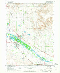
1965 Map of Courthouse Rock
USGS Topo · Published 1967About this map
Courthouse Rock and Jail Rock dominate the landscape in this mid-1960s study of Nebraska's Panhandle, serving as prominent geological landmarks for travelers long before modern surveying. The map traces the historical path of the Emigrant Trail across the northern sections, illustrating the enduring geography of westward expansion. Water management is a central theme of this Morrill County terrain, with a complex network of irrigation infrastructure including the Last Chance Canal, Courthouse Rock Canal, and the Meredith Ammer Canal siphoning from Pumpkin Creek.
Find a feature on this map
19 named features on this map. Tap any name to fly to it.
Don’t see what you’re looking for? This feature index may not catch every label — zoom into the map to look around manually.
Map Details
Editions of this 1965 Courthouse Rock Map
This is the sole edition of this map. No revisions or reprints were ever made.
Other maps of this area

1896 · Browns Creek
USGS Topo · 1:125,000

1898 · Camp Clarke
USGS Topo · 1:125,000

1899 · Browns Creek
USGS Topo · 1:125,000

1899 · Sidney
USGS Topo · 1:125,000

1954 · Scottsbluff
USGS Topo · 1:250,000

1958 · Scottsbluff
USGS Topo · 1:250,000

1965 · Bridgeport NW
USGS Topo · 1:24,000

1965 · Broadwater NW
USGS Topo · 1:24,000
1965 · Bridgeport
USGS Topo · 1:24,000

1965 · Broadwater SW
USGS Topo · 1:24,000