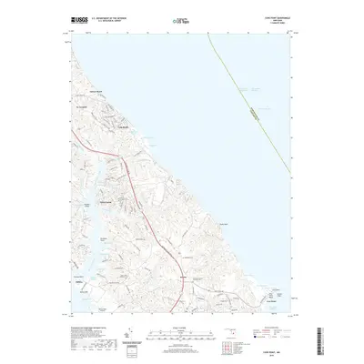
2019 Map of Cove Point
USGS Topo · Published 2019About this map
Cove Point and the dramatic shoreline of the Chesapeake Bay define this coastal portion of Calvert County. The landscape is characterized by a series of deeply inset coves and creeks, most notably Saint Leonard Creek and Johns Creek, which create a complex network of peninsulas. Along these shores, established communities such as White Sands, Brooms Island, and Calvert Beach are visible. The map records several sites of local historical and genealogical significance, including the Middleham Cem and Saint Paul United Methodist Cem. Inland from the Calvert Cliffs, the terrain is marked by numerous small branches and ponds, such as Richardsons Pond and Todds Pond, showing the intricate drainage patterns that lead to the bay. Small-scale aviation history is noted at the Mears Creek Airfield, while the eastern boundary follows the Chesapeake Channel through the bay.
Find a feature on this map
112 named features on this map. Tap any name to fly to it.
Don’t see what you’re looking for? This feature index may not catch every label — zoom into the map to look around manually.
Map Details
Editions of this 2019 Cove Point Map
This is the sole edition of this map. No revisions or reprints were ever made.
Other maps of this area

1892 · Leonardtown
USGS Topo · 1:62,500

1892 · Drum Point
USGS Topo · 1:62,500

1892 · Prince Frederick
USGS Topo · 1:62,500

1893 · Sharps Island
USGS Topo · 1:62,500

1895 · Prince Frederick
USGS Topo · 1:62,500

1895 · Leonardtown
USGS Topo · 1:62,500

1895 · Nomini
USGS Topo · 1:125,000

1898 · Choptank
USGS Topo · 1:125,000

1898 · Nomini
USGS Topo · 1:125,000

1898 · St. Marys
USGS Topo · 1:125,000