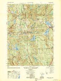
1950 Map of Coventry
USGS Topo · Published 1950About this map
Potterville and Greene anchor this mid-century view of western Rhode Island, where the landscape is defined by a dense network of reservoirs and small rural settlements. The New York New Haven and Hartford rail line cuts an east-west path through the center of the quadrangle, passing through Summit and connecting the remote farmsteads and schoolhouses. Local civic life is centered around institutions like the Mt Vernon Ch and several small schoolhouses, including the Plain Meeting House Sch and Maple Valley Sch, which served the scattered populations of Coventry and West Greenwich.
Find a feature on this map
49 named features on this map. Tap any name to fly to it.
Don’t see what you’re looking for? This feature index may not catch every label — zoom into the map to look around manually.
Map Details
Editions of this 1950 Coventry Map
This is the sole edition of this map. No revisions or reprints were ever made.
Other maps of this area

1889 · Putnam
USGS Topo · 1:62,500

1889 · Burrillville
USGS Topo · 1:62,500

1889 · Moosup
USGS Topo · 1:62,500

1890 · Kent
USGS Topo · 1:62,500

1893 · Putnam
USGS Topo · 1:62,500

1893 · Moosup
USGS Topo · 1:62,500

1894 · Burrillville
USGS Topo · 1:62,500

1894 · Kent
USGS Topo · 1:62,500

1915 · Burrillville
USGS Topo · 1:62,500

1919 · Putnam
USGS Topo · 1:62,500