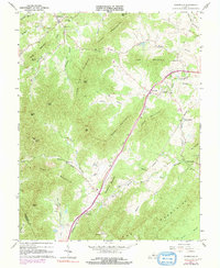
1967 Map of Covesville
USGS Topo · Published 1991About this map
The Southern railroad corridor anchors this Virginia Piedmont landscape, winding through the narrow valleys between Chalk Mountain and Cook Mountain. Orchards and agriculture define the valley floor near Covesville, where the railway provided a vital link for the region's produce. The terrain is defined by the high ridges of the Boaz Mountains and Fan Mountains, with several prominent gaps like Israel Gap serving as traditional transit points between the watersheds of the Mechums River and the Hardware River. Numerous rural landmarks suggest a long-established community structure, from the Red Hill Sch to scattered houses of worship like Mt Ed Ch, Zion Ch, and Bethel Ch. Further north, the settlement of Batesville sits at the foot of Israel Mountain, while the distinct villages of North Garden and South Garden mark the lower elevations where the Jumping Branch meets the main river channel.
Find a feature on this map
55 named features on this map. Tap any name to fly to it.
Don’t see what you’re looking for? This feature index may not catch every label — zoom into the map to look around manually.
Map Details
Editions of this 1967 Covesville Map
3 editions found
Other maps of this area

1892 · Buckingham
USGS Topo · 1:125,000

1892 · Harrisonburg
USGS Topo · 1:125,000

1929 · Covesville
USGS Topo · 1:62,500

1931 · University
USGS Topo · 1:62,500

1934 · Waynesboro
USGS Topo · 1:48,000

1935 · Covesville
USGS Topo · 1:62,500

1935 · University
USGS Topo · 1:62,500

1939 · Waynesboro
USGS Topo · 1:62,500

1943 · Lovingston
USGS Topo · 1:62,500

1945 · Covesville
USGS Topo · 1:62,500